Wind, storm and hail forecasts for the sites you run

Tomorrow’s work, checked against your limits.

A 1 km forecast of your site, checked against your storm, wind and cut-out limits. You make the call.

Start free trial

14 days · 3 saved sites · 20 credits · card required

A short form; our team replies by email.
  • Wind farm
  • Crane / worksite
  • Runway
  • Property
  • Single turbine
  • General site
Illustrations
$12.50
a 12-hour storm forecast for your US site, at 1 km
62min
from order to a finished 12-hour hail forecast, on one GPU
1km
grid spacing, three times finer than the US national model’s 3 km

Wind farm: hub height, cut-out speed · Crane / worksite: boom-tip height · Runway: heading, length, crosswind limit. Email alerts today: storm, lightning, National Weather Service and saved wind-limit checks (US).

Live today

What you can run today

Icons, not forecast output

Live

Wind forecast · 1 km

A 400 km run around your site, with wind at the heights you choose, hub height included, and the turbine cut-out check.

  • US
  • 1 km
  • 6–24 h
  • 6–18 credits
See how it works

Live

Storm and hail forecasts · 1 km

Storms and HAILCAST hail sizes over a 500 km square, in the US. Storm forecasts are not yet scored against observations.

  • US
  • 1 km
  • up to 12 h
  • 3–12 credits
See how it works

Live · preview (unscored)

Worldwide wind forecast (experimental) · MPAS

Hub-height wind, gust, shear, veer and ramps almost anywhere from 80°S to 80°N (not across the 180° meridian), on a 3 km hexagonal mesh. Not yet scored against observations.

  • 80°S–80°N
  • 3 km
  • 12 h
  • 12 credits
See how it works

Live

Standing watch and email alerts

Every saved site is re-checked every 15 minutes against the latest published StormScope nowcast cycle (US). An email goes out when a site newly crosses its storm limit (35 dBZ unless you set your own).

  • Every 15 min
  • US
  • Email
See how it works

Live

Logbook

A per-site record of every check: what the forecast said, against which threshold, and what was not assessed.

  • Per site
  • Per cycle
See how it works

Wind operations

Hub-height wind at your turbines, at the heights you choose.

Hub-height wind 1 km · US
Wind at up to 16 heights you choose, hub height included, from a model run around your site.
Turbine cut-out check Weather Risk
Hub-height wind as a 10-minute mean against each turbine’s saved cut-out speed. Asset protection, never a safety verdict.

Worldwide wind forecast (experimental), unscored

Hub-height wind, worldwide
Wind at 80, 120, 150 and 200 m, almost anywhere from 80°S to 80°N (not across the 180° meridian).
Ramps
The one-hour change in wind speed at 100 m.
Shear and veer
Across the rotor layer, 40 to 160 m.
Gust and turbulence
Gust at 10 m and turbulence kinetic energy at 100 m.

Worldwide wind forecast (experimental): unscored. Hub-height winds (80–200 m), 10 m gust, turbulence (TKE), rotor-layer shear and veer, and 1 h wind-speed change are produced by the model but not yet scored against observations.
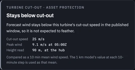
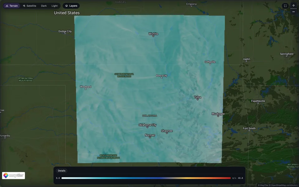
The turbine cut-out card: forecast wind stays below this turbine’s 25 m/s cut-out speed, peaking at 9.1 m/s at the 90 m hub, compared as a 10-minute mean.The Aerava run viewer showing a 1 km wind forecast at 90 m over northern Oklahoma and southern Kansas, from Wichita to Norman, with fine streaks of stronger wind across the domain.
Run viewer · 1 km wind at 90 m hub height · King Plains, Oklahoma · Sep 23, 2026, 08:50 UTC · model output

Weather Risk · turbine cut-out check · King Plains Turbine A1 (test site) · from the same 1 km run of Sep 23, 2026, 01:00 UTC · peak at 05:00 UTC that morning
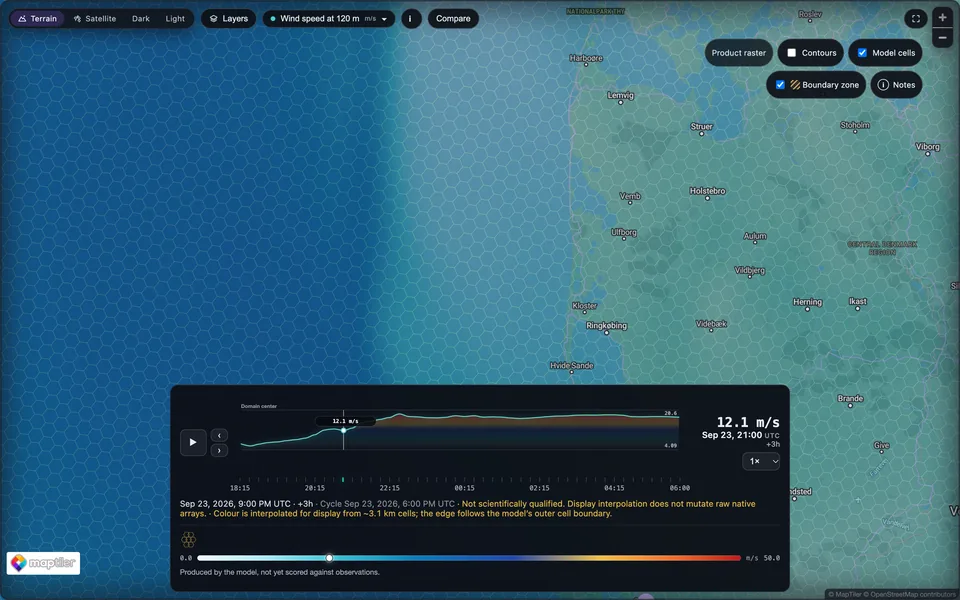
Close-up of the worldwide wind forecast (experimental) over the west coast of Jutland with the model’s own hexagonal cells, about 3 km across, drawn over the 120 m wind field.
Run viewer · model cells on · worldwide wind forecast (experimental), unscored · 120 m · west Jutland · Sep 23, 2026, 21:00 UTC · ~3.1 km hexagons

Standing watch

Your sites are checked every 15 minutes.

Aerava re-checks every saved site every 15 minutes against the latest published StormScope cycle (US), and records what it found.

Aerava emails you when a site newly crosses its storm limit (35 dBZ unless you set your own), when lightning is forecast at it, when an active National Weather Service alert covers it, or when your own wind forecast for it crosses a wind limit you saved. Telegram is to follow. The turbine cut-out check is shown on Weather Risk beside the storm check, never alerted.

The standing watch does not check a crane’s boom-tip wind limit, a runway’s crosswind limit or a gust limit. Missing, withheld and not-yet-evaluated are shown as exactly that; absence is never a clear-weather signal.

Each StormScope cycle looks six hours ahead and takes about an hour to publish, so for roughly an hour in every six there is no current forecast for a site; that stretch is shown as expired, never as clear.
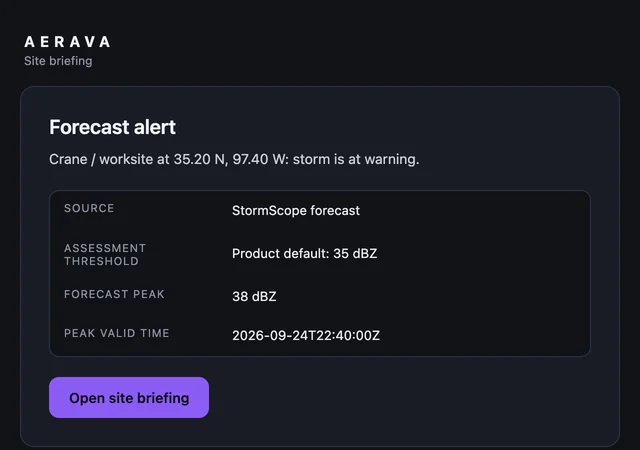
An Aerava forecast alert email: the crane test site’s storm check is at warning, StormScope forecast peak 38 dBZ against a 35 dBZ threshold, valid 22:40 UTC.
The alert of Sep 24, 2026, 19:05 UTC in today’s email template · crane test site · recipient replaced View full size (opens in a new tab)

Logbook

Every check, written down, per site and per cycle.

What the forecast said for each site, the threshold it was held to, which hazards were not assessed, and the notes and decisions your team adds. The record does not yet hold an observation for each claim, so no entry is marked right or wrong: it says so instead.
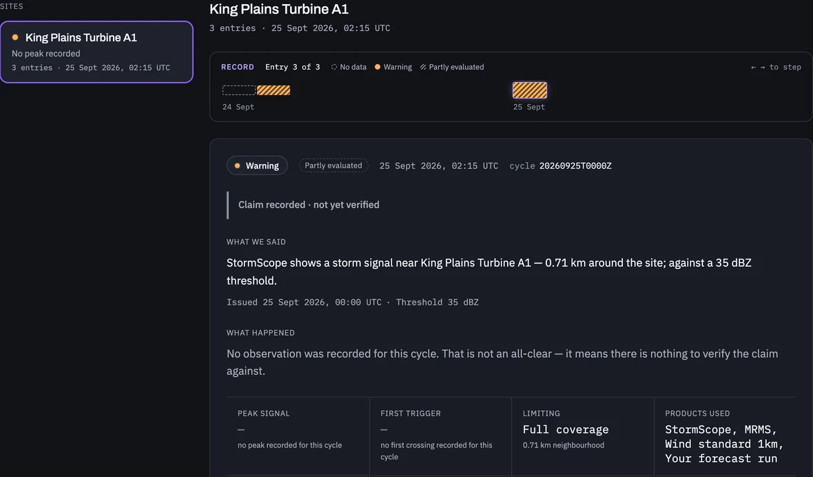
A Logbook site record for King Plains Turbine A1: a strip of forecast cycles, then one cycle’s entry showing what the forecast said, that no observation was recorded to verify it, and the products used.
Logbook · King Plains Turbine A1 (test site) · StormScope cycle Sep 25, 2026, 00:00 UTC · 3 cycle entries from real logbook records, ids replaced View full size (opens in a new tab)

Proof

Real forecasts, with where and when printed under each.

Every image below is output from a forecast we ran. Where we scored a forecast against observations, the misses are shown with the hits; where we have not, it says so.
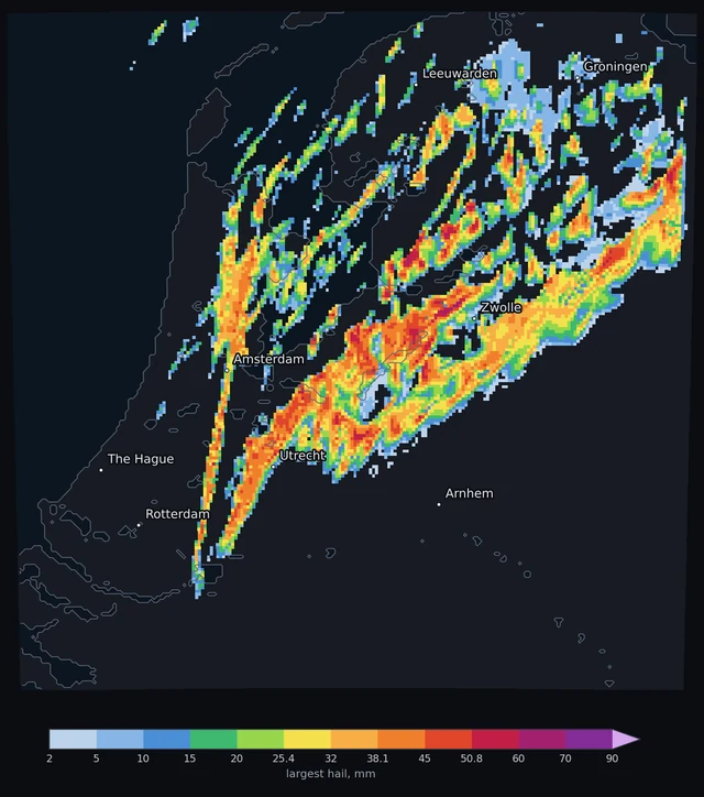
Forecast map of the largest hail over the Netherlands on the evening of Jun 27, 2026: a swath of large hail running southwest to northeast from near Rotterdam and Utrecht past Zwolle, colored from 2 mm to 90 mm, with major cities labeled.
Largest hail at each point over a 5-hour forecast from Jun 27, 2026, 18:00 UTC (HAILCAST, maximum 69 mm) · Netherlands · 1 km cells over a 220 km run · ICON-D2 initial conditions · coast from the model’s own land mask · cities for orientation

Hail

Available now · US

Hail grown inside the storm, not guessed after it.

HAILCAST runs inside the forecast model and grows hailstones through each storm’s updraft as the storm develops, so the size you see comes from the storm the model built rather than from a rule of thumb applied afterward. One run covers a 500 km square at 1 km.

The image is one of our forecasts for the evening of Jun 27, 2026, over the Netherlands, a smaller 220 km run: the largest hail it grew at each point over five hours, cell by cell at 1 km.

Area
500 km
Detail
1 km
Ahead
up to 12 h
Price
4–12 credits

Hail size is experimental guidance, not yet systematically scored. Judge where it puts the hail first, and how big second.

Wind, measured

Research · not a product claim

Twelve nights against real lidar, misses included.

We ran our 1 km wind forecast over twelve nights at an 88-turbine wind farm in Oklahoma and scored it every ten minutes against public DOE lidar at 80 m. Blended with the US national model (HRRR), it had 11 to 13 percent less error than the national model alone, and was better on 11 of 12 nights.

On its own, the 1 km run did not reliably beat HRRR at the tower. The 11 to 13 percent figure is the blend, which is research and not on sale. What you can buy is the 1 km run itself.

Nights
12
Better on
11 of 12
Height
80 m

11–13%

less error at 80 m than the US national model, over 12 nights of lidar at two towers of a US wind farm.

Average wind-speed error, m/s · shorter is better

Tower A1 −12.9%

US national model2.58
Aerava blend2.25

Tower H −11.3%

US national model2.46
Aerava blend2.18

Better on 11 of 12 nights at both towers.

The engine

Aerava is new. AceCAST, the GPU weather engine under it, is not.

AceCAST is Aerava’s core engine: WRF, the weather model forecasters and researchers use worldwide, built to run natively on NVIDIA GPUs. That is what buys 1 km detail around one site at a price per forecast, and a 12-hour hail forecast in 62 minutes from order to finish, on one GPU. Here is what others have measured and said about it.

“We observed only minimal variances between WRF and AceCAST.”
Veer Renewables, 2023 (PDF, opens in a new tab)
“AceCAST runs 7% faster at 75% lower cost than CPU-based WRF.”
Microsoft and TempoQuest, NVIDIA Technical Blog, April 2023 (opens in a new tab)

Where Aerava is going: MPAS, one global model on a hexagonal mesh. Today it runs the worldwide wind forecast (experimental), almost anywhere from 80°S to 80°N (not across the 180° meridian). Its layers are not yet scored against observations, and we will publish scores before we call it anything more.

Pricing

Wind from $7.50 · Storm from $3.75

The price is shown before you run.

What one forecast costs

  • Storm forecast500 km at 1 km · 1–12 h3–10 credits$3.75–$12.50
  • Hail forecast500 km at 1 km · 1–12 h4–12 credits$5–$15
  • Wind forecast400 km at 1 km · 6–24 h6–18 credits$7.50–$22.50
  • Worldwide wind forecast (experimental)Preview · 400 km at 3 km · 12 h12 credits$15

Longer forecasts cost more; the exact price is shown before you run. Dollars at credit-pack prices, less on a plan.

Starter

$49per month

  • 40 credits a month
  • 3 saved sites
  • Standing watch with email alerts (US sites)
Start free trial

For businesses only. To create an account or buy, you must be 18 or older and acting for a business or organization.

14-day free trial on either plan · 3 saved sites · 20 credits · card required · one free trial per customer. After the trial, the plan renews monthly at its price until you cancel in Billing.

Unused monthly credits roll over and stay usable after you cancel.

Credits held for a run are returned to your balance automatically when the run fails, cannot be submitted or is canceled before it starts running. Returned credits are credits, not money. Subscription fees and credit-pack purchases are not refundable, except a plan charge made after your cancellation email, sent from your account email to support@tempoquest.com, reached us and before we carried it out (Terms, Sections 8 and 11).

Maps, charts, point series, tables and Logbook history are kept until you ask us to delete them or your account is closed. Raw model output and data packages are available for at least 30 days after each run.

Running a fleet or a portfolio?

Credit packs

  • 20 credits$25
  • 50 credits$62.50
  • 100 credits$125
  • 250 credits$312.50

Packs are available on any plan.

Questions

What people ask first

What is Aerava?
Aerava is a weather intelligence platform. You pin a site, choose a forecast, and Aerava runs a full numerical weather model for that place, then checks the result against the storm, wind and cut-out limits you set. Wind, storm and hail forecasts run on AceCAST, Aerava’s GPU-native build of the WRF weather model; the worldwide wind forecast (experimental) runs on MPAS.
Which forecasts can I run today?
Wind forecasts at 1 km with wind at the heights you choose, hub height included, 6 to 24 hours ahead, in the US. Storm and hail forecasts over a 500 km square at 1 km, up to 12 hours ahead, in the US; hail sizes come from HAILCAST, which grows hailstones inside the model’s own storms. A worldwide wind forecast, an experimental preview on the MPAS model, with wind at 80 to 200 m, gust, shear, veer and ramps almost anywhere from 80°S to 80°N (not across the 180° meridian).
How do alerts work?
Save a site and set its limits. Every 15 minutes Aerava re-checks every saved site against the latest published StormScope nowcast cycle over the US. Each StormScope cycle looks six hours ahead and takes about an hour to publish, so for roughly an hour in every six there is no current forecast for a site; that stretch is shown as expired, never as clear. Aerava emails you when a site newly crosses its storm limit (35 dBZ unless you set your own), when lightning is forecast at it, when an active National Weather Service alert covers it, or when your own wind forecast for it crosses a wind limit you saved. Telegram is to follow. The turbine cut-out check compares hub-height wind, as a 10-minute mean, against each turbine’s saved cut-out speed. It is shown on Weather Risk beside the storm check and never alerted: it is asset protection, never a safety verdict. Missing, withheld and not-yet-evaluated are shown as exactly that, never as clear.
How fast is a forecast?
A 12-hour hail forecast, 500 km across at 1 km, took 62 minutes from order to finished forecast on one GPU (Sep 28, 2026). Storm forecasts run on the same pipeline. Times vary with the weather and the queue.
How much does a forecast cost?
Forecasts are priced in credits and the price is shown before you run. A wind forecast is 6 to 18 credits, a storm forecast 3 to 10, a hail forecast 4 to 12, depending on how far ahead it looks, and the worldwide wind forecast (experimental) 12. Credit packs are $1.25 a credit; the Starter plan is $49 a month with 40 credits and Pro is $149 a month with 150. Either plan starts with a 14-day free trial: 3 saved sites, 20 credits, card required, one free trial per customer. After the trial, the plan renews monthly at its price until you cancel in Billing. Unused monthly credits roll over and stay usable after you cancel.
What if a run fails?
Credits held for a run are returned to your balance automatically when the run fails, cannot be submitted or is canceled before it starts running. Returned credits are credits, not money. Subscription fees and credit-pack purchases are not refundable, except a plan charge made after your cancellation email, sent from your account email to support@tempoquest.com, reached us and before we carried it out (Terms, Sections 8 and 11).
How long are run files kept?
Maps, charts, point series, tables and Logbook history are kept until you ask us to delete them or your account is closed. Raw model output (such as wrfout files) and data packages (NetCDF files, table exports such as CSV files, and data-pack zips) are available for at least 30 days after each run, so download anything you want to keep within 30 days. Leftover files from a failed run may be deleted 7 days after it failed.
Who can buy Aerava?
Businesses and organizations, including self-employed professionals buying for their work. To create an account or buy, you must be 18 or older and acting for a business or organization. Aerava is not sold to consumers.
How accurate is it?
We publish what we measured, misses included. Over twelve nights in 2023 at an 88-turbine Oklahoma wind farm, scored every ten minutes against public DOE AWAKEN lidar at 80 m, our 1 km forecast blended with the US national model (HRRR) had 11 to 13 percent less error than HRRR alone, and was better on 11 of 12 nights. On its own, the 1 km run did not reliably beat HRRR at the tower. The blend is research and not on sale; what you buy is the 1 km run. Storm forecasts are not yet scored against observations; hail size is experimental guidance, not yet systematically scored. For the worldwide wind forecast (experimental): Hub-height winds (80–200 m), 10 m gust, turbulence (TKE), rotor-layer shear and veer, and 1 h wind-speed change are produced by the model but not yet scored against observations.
What is AceCAST?
AceCAST is Aerava’s core engine: the WRF weather model, built to run natively on NVIDIA GPUs. In a benchmark published on the NVIDIA Technical Blog in April 2023 it ran 7% faster at 75% lower cost than CPU-based WRF, and Veer Renewables in 2023 “observed only minimal variances between WRF and AceCAST.”
Does the 1 km run beat HRRR?
Not reliably at a single tower on its own; in our twelve-night Oklahoma test the gain came from the blend, which is not on sale. HRRR publishes hub-height wind too. What the 1 km run adds: a 400 km run around your site at 1 km, wind at up to 16 heights you choose, the cut-out check, standing watch and a record. Judge it on your site during the trial.
How far ahead does it go?
Wind: 6 to 24 hours (US). Storm and hail: up to 12 hours. Worldwide wind forecast (experimental): 12 hours.
What do I see when there is no data?
Exactly that. Missing, withheld and not-yet-evaluated are labeled as such in Weather Risk and the Logbook. Absence is never a clear-weather signal.
Is this a safety system?
No. The cut-out check and standing watch are asset protection, never a safety verdict. The Logbook records what the forecast said and what was not assessed; no entry is marked right or wrong yet.